Walking Tour
Welcome! Prepare to embark on a unique, informative tour of the largest and arguably most diverse park in all of Seattle.
 |
| Aerial shot of Discovery Park in its entirety, with some of the Magnolia neighborhood in the bottom right. |
 |
This is a view of my 'site,' the particular area that I studied and observed over the past 10 weeks. The numbers mark the general locations of my 10 'stations.' The blue line marks the trail obscured by the trees that goes from the bluff to the shore. Ideally the tide is low so the tide-flats featured in some of my stations are accessible!
|
Station 1: Land-Use History—Previous Settlement and Fort Lawton
Discovery Park, has a rich history of human use dating back more than four thousand years. In 1992, a geologist accidentally discovered cultural deposits while digging for the construction of a pipeline. From an extensive excavation procedure, archaeologists found a plethora of artifacts and other indicators that Native American tribes such as the Duwamish, Muckleshoot, and Suquamish lived on and used the land for millennia. The site was inhabited year-round, used as a trade post, and as a place to harvest the rich tidal environment for primarily mussels.
 |
| The West Point Lighthouse (tip of the point) and Water Treatment Plant, where evidence of Native inhabitance spanning thousands of years was found. Photo courtesy of kingcounty.gov. |
In the mid to late 1800s, there were no longer native inhabitants and the land was used and claimed by European settlers. The site was logged, likely causing the destruction of whatever old-growth there may have been. A lighthouse was built in 1881, and by 1900 the land had been turned over to the U.S. Army and designated as Fort Lawton.
The fort saw minimal military use until World War II, and since 1917 there had been efforts to revert the land into public park. At one point, the Army offered the land to the City of Seattle for one dollar, but the City declined the offer to avoid paying for the land’s maintenance costs. During the war, it was used as a point of embarkation and housed Italian and German prisoners of war. In the 1950s and 1960s, it was used for various military purposes such as housing anti-aircraft missiles.
Then, in 1973, most of the land was given to the city and had been named Discovery Park in dedication to the HMS Discovery, the vessel captained by George Vancouver that explored the Sound in 1792. Seventeen acres of the park was leased to the United Indians of All Tribes, which constructed the Daybreak Star Cultural Center. Therefore, the park has only had its current status for about 45 years, and even now there are areas of private property with historic homes for sale. It’s difficult to identify the exact impacts that such an eventful past would have on the biology and geology of the site, but some artifacts of past disturbances still remain.
Below are some images I took of what appear to be industrial remnants of structures. Many buildings such as barracks and lodging for POWs were only used temporarily and were demolished long ago.
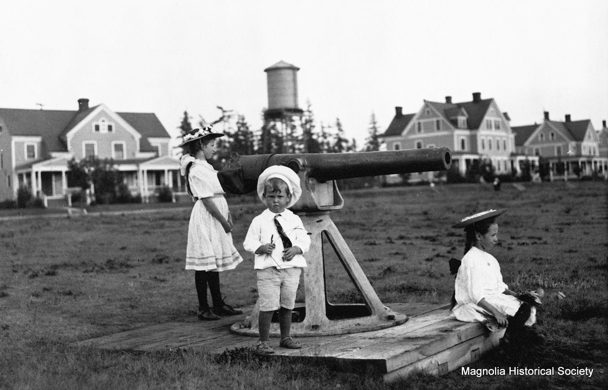 |
| Image of Fort Lawton from 1900. Photo from Magnolia Historical Society |
The fort saw minimal military use until World War II, and since 1917 there had been efforts to revert the land into public park. At one point, the Army offered the land to the City of Seattle for one dollar, but the City declined the offer to avoid paying for the land’s maintenance costs. During the war, it was used as a point of embarkation and housed Italian and German prisoners of war. In the 1950s and 1960s, it was used for various military purposes such as housing anti-aircraft missiles.
 |
| Shot from around the 1950s featuring the Nike anti-air missile station in the center. Photo from Paul Dorpat's website pauldorpat.com |
Then, in 1973, most of the land was given to the city and had been named Discovery Park in dedication to the HMS Discovery, the vessel captained by George Vancouver that explored the Sound in 1792. Seventeen acres of the park was leased to the United Indians of All Tribes, which constructed the Daybreak Star Cultural Center. Therefore, the park has only had its current status for about 45 years, and even now there are areas of private property with historic homes for sale. It’s difficult to identify the exact impacts that such an eventful past would have on the biology and geology of the site, but some artifacts of past disturbances still remain.
Below are some images I took of what appear to be industrial remnants of structures. Many buildings such as barracks and lodging for POWs were only used temporarily and were demolished long ago.
 |
| Large concrete slabs that were perhaps part of a building's foundation |
 |
| An iron rail fitted into concrete. Again, it probably served some structural purpose. |
Station 2: Geomorphology—Lawton Clay and Esperance Sand divide on the beach
My site lies beneath Magnolia Bluff, a two hundred and fifty feet tall cliff that leaves exposed many sedimentary layers. In fact, Discovery Park is often cited as a great place to study the geological history of the Puget Sound because of the exposed sediments that lie above ground and require no excavation to observe. Although I’m sure there is a large amount of geological information that the bluff can teach, the most obvious and interesting thing to me is the divide between the layer of Esperance Sand and the layer of Lawton Clay.
Glacial meltwaters from the Puget Lobe of the Vashon Ice sheet eroded dark, grey-blue clay and silt (Lawton Clay) which accumulated at the bottom of Great Lake Russel, an enormous lake that covered the modern day Puget Sound region. The Esperance Sand layer lies above the clay and consists of weak, yellowish sand that was deposited in faster moving glacial meltwaters during the glacier’s advance. The difference in the two layers is drastic: at some places on the beach, you can find odd formations of hard clay that seemingly come out of the ground among the tide-flats, meanwhile on the walk down to the beach you’ll be slipping on soft sand.
Many self-centered people enjoy defacing the impressive geological history and writing their names in the clay, although I’d imagine archaeologists would have loved to discover writings of ancient tribespeople. It is somewhat difficult to tell the exact place where the sand meets to clay because the sand is easily eroded over the clay, but near the base of the bluff there is a somewhat clear divide that demonstrates the difference in appearance.
 |
| In this photo, the Lawton Clay layer ranges from the ground up to (about) where the grass and shrubs are growing. |
Glacial meltwaters from the Puget Lobe of the Vashon Ice sheet eroded dark, grey-blue clay and silt (Lawton Clay) which accumulated at the bottom of Great Lake Russel, an enormous lake that covered the modern day Puget Sound region. The Esperance Sand layer lies above the clay and consists of weak, yellowish sand that was deposited in faster moving glacial meltwaters during the glacier’s advance. The difference in the two layers is drastic: at some places on the beach, you can find odd formations of hard clay that seemingly come out of the ground among the tide-flats, meanwhile on the walk down to the beach you’ll be slipping on soft sand.
 |
| I took this shot of a Northern Alligator Lizard while walking up to the top of the bluff, and therefore within the Esperance Sand layer. |
Many self-centered people enjoy defacing the impressive geological history and writing their names in the clay, although I’d imagine archaeologists would have loved to discover writings of ancient tribespeople. It is somewhat difficult to tell the exact place where the sand meets to clay because the sand is easily eroded over the clay, but near the base of the bluff there is a somewhat clear divide that demonstrates the difference in appearance.
Station 3: Invertebrate—Oregon Shore Crab


Situated between the sandy Magnolia Bluff and the Puget Sound, my site has a significant variety of species and ecosystems. A particularly interesting ecosystem that I documented were the tide-flats, where I found many extraordinary creatures and witnessed their behaviors. One species of great abundance there was the Oregon Shore Crab (Hemigrapsus oregonensis). Also known as the Yellow, Green, Mud-flat, and Hairy Shore Crab, this small (~1-1.5 inch) crustacean ranges in color from green to yellow to grey, but those I observed almost all had a greenish-grey tinge. I would hypothesize that this color is an adaptive trait, as the crabs are thoroughly camouflaged in their environment of sand, rocks, and green algae/plants. They live beneath rocks and other objects on the tide-flats. The combination of camouflage and a reclusive habitat protects the crabs from predation from shore birds and crows, which I witnessed walking around the shore, pecking under rocks and other objects looking for food.
Oregon Shore Crabs can be distinguished by the small hairs on their legs called setae that serve mechanical and sensory functions. Other small crustaceans are easily differentiated from this crab by their colors and exterior patterns such as the related Purple Shore Crab. (Washington Department of Fish and Wildlife).

Don't worry! I flipped the rock back over.
Oregon Shore Crabs can be distinguished by the small hairs on their legs called setae that serve mechanical and sensory functions. Other small crustaceans are easily differentiated from this crab by their colors and exterior patterns such as the related Purple Shore Crab. (Washington Department of Fish and Wildlife).
Station 4: Birds—Red-Tailed Hawk, Song Sparrow
 |
| Photo from audubon.org, there's no way I could take a picture this good with my phone! |
The elusive Red-Tailed Hawk (Buteo jamaicaensis) is a large (~4 foot) raptor that can be found all across Washington as well as a large majority of North America. It’s characteristic “keee—yaa” call epitomizes the ‘call of the wild,’ and therefore is often used as a soundbite in films (often to voiceover the less impressive voice of Bald Eagles).
This raptor can be seen casually gliding with its enormous wingspan, usually above the beach at my site, and usually accompanied by pestering crows. As they perch high up in coastal treetops, it is difficult to get a close look at them. However, it is quite easy to recognize the white and brown streaked underside as well as the reddish tail of the hawk whilst in flight.
Another bird that I feel is essential to my site is the Song Sparrow (Melospiza melodia) because I spent many hours enjoying their company there. They are small, brown birds with white spots that crescendo in frequency beginning at the breast and going down towards its mostly-white underparts.

Sometimes their tail will be erect in a seemingly alert position. They dwell close to the ground in shrubs and lower branches of trees. Song Sparrow songs are distinct in their melodies but similar in their complexity and general structure, and they use a “chimp” call as a way to alert others of danger. I imitated their calls with the Audubon Birds app and each time multiple sparrows would dutifully come to greet me with confusion and song.
Station 5: Biotic Interaction—Gulls and Crows Feeding on Crabs
For one of the journal assignments, we were given the task of finding and following birds and observing their behaviors. I waited around my site for a while keeping an eye out for some feathered friends, but the only ones I saw in the vicinity were song sparrows. Although they exhibit incredible singing behavior, I figured that since we had learned about it in class already I should try to find some other birds to document. Luckily it was low tide, so I went down to the tide-flats to see if I could find something interesting, because usually you can find hawks, eagles, and herons there. I walked south along the shore and noticed a large group of (likely glaucous and western and hybrids) gulls and American Crows, numbering about 50 individuals, walking around by the water. After making a few sketches of the crows, I witnessed some truly peculiar behavior and interactions between the species. Both types of birds would be quietly looking down at the rocks pecking around for clams (and crabs, although I’m not positive as it was difficult to see). Then, a bird (usually a gull) would find a clam and take it up into the air and drop it in an attempt to crush its shell and access its meaty interior.
This is some truly impressive behavior to begin with, but there was even more going on. Crows, who seemed to be significantly worse—but perhaps were just lazier—at locating prey would watch the gulls from a short distance away, waiting for them to pull one out from the sand or underneath rocks. Once they saw the emerged clam, the crows would sweep in, snatch it, and make a break for it, flying away to a safe distance. More often than not, the gulls would follow and cause the crows to cede the food that wasn’t rightfully theirs, maybe because the gulls outsized them significantly. However, crows would occasionally succeed in their thievery and would share the meal with other crows. A couple times after a failure, the crows would mob together and exhibit their characteristic, harsh caws and berate the gulls that outmaneuvered or bested them.
Although likely awkward and strenuous for the birds, for me this interaction was a great display of animal behavior. Not only are the birds tactfully, and intelligently utilizing the force of gravity to extract food from clams, they are also exhibiting Darwinian competition that plays a direct role in the success of the species. Even if there was plenty of food for all of them, the crows were using their intelligence to get the upper hand against the gulls by making them do the hard work for them. This competitive interaction also gave me insight as to why the shore crabs hide so diligently under the rocks of the tide-flats.
 |
| A Western Gull drops a clam. Photo from Wimikedia Commons |
This is some truly impressive behavior to begin with, but there was even more going on. Crows, who seemed to be significantly worse—but perhaps were just lazier—at locating prey would watch the gulls from a short distance away, waiting for them to pull one out from the sand or underneath rocks. Once they saw the emerged clam, the crows would sweep in, snatch it, and make a break for it, flying away to a safe distance. More often than not, the gulls would follow and cause the crows to cede the food that wasn’t rightfully theirs, maybe because the gulls outsized them significantly. However, crows would occasionally succeed in their thievery and would share the meal with other crows. A couple times after a failure, the crows would mob together and exhibit their characteristic, harsh caws and berate the gulls that outmaneuvered or bested them.
 |
| Similar scene as to what I witnessed but didn't get photos of. Crows watch on as the gull works to secure the food. Photo citation within the photo. |
Although likely awkward and strenuous for the birds, for me this interaction was a great display of animal behavior. Not only are the birds tactfully, and intelligently utilizing the force of gravity to extract food from clams, they are also exhibiting Darwinian competition that plays a direct role in the success of the species. Even if there was plenty of food for all of them, the crows were using their intelligence to get the upper hand against the gulls by making them do the hard work for them. This competitive interaction also gave me insight as to why the shore crabs hide so diligently under the rocks of the tide-flats.
Station 6: Animal Behavior—Crows Mobbing Eagles and Hawks
Most of the animals I was able to observe for significant periods of time were avian species. The most interesting behavior I saw was the interaction the between crows, gulls, and clams. However, I also witnessed an intriguing behavior performed by crows in response to large raptors. Bald Eagles, and even more often, Red Tailed Hawks, can be found flying above my site. However, like sharks and their pilot fish, the raptors were always accompanied by a few crows who flew closely behind. The crows follow behind the enormous bird berating it and trying to dive-bomb it and peck at its back. This behavior is known as mobbing, and it is performed to ward off large predators that pose threats to crows and their offspring.
It may seem odd that crows, birds far smaller and less dangerous than a Hawk or Eagle would engage the threat head on. However, their small size grants them better maneuverability in the air which lets them evade the raptor should it try to chase or attack them. The mobbing response demonstrates a certain level of self-awareness or intelligence in creatures that do it: crows understand that they are threatened by a more powerful animal, however they also recognize the weakness of the raptor and are able to harass it and dispel it. Perhaps they understand that they would forfeit their offspring if they abandoned the nest, so the only choice they have is to defend via offense, and they happen to be able to fare well in a quarrel against larger predators. Instead of responding to danger with 'fight or flight', crows do both.
 |
| Photo-2011 John C. Avise, University of California Irvine |
It may seem odd that crows, birds far smaller and less dangerous than a Hawk or Eagle would engage the threat head on. However, their small size grants them better maneuverability in the air which lets them evade the raptor should it try to chase or attack them. The mobbing response demonstrates a certain level of self-awareness or intelligence in creatures that do it: crows understand that they are threatened by a more powerful animal, however they also recognize the weakness of the raptor and are able to harass it and dispel it. Perhaps they understand that they would forfeit their offspring if they abandoned the nest, so the only choice they have is to defend via offense, and they happen to be able to fare well in a quarrel against larger predators. Instead of responding to danger with 'fight or flight', crows do both.
Station 7: Plant—Bigleaf Maple


Bigleaf Maple (Acer macrophyllum) is one of the most abundant deciduous trees in the Puget Sound region. It dominates the canopy around my site leaving room for few comparably tall trees, such as Red Alder. During the first few weeks of observing my site, which was before the leaves had grown, I had been mistaking the Maples for Alders due to a few similarities: they are both deciduous, found at low elevations, and serve as early successional trees after a clearing. Furthermore, Alders often are in pure stands, and the stand at my site is almost purely Maples. However now that spring has sprung, the distinct, massive, five-loved leaves of the Maples have emerged.

Other characteristics of Bigleaf Maples are an opposite branching pattern, ‘winged’ seeds (samaras), and thoroughly textured bark that often has curved ‘veins’ that stretch the tree vertically. Also, the trees commonly have high saturations of mosses, fungi, and lichen on their exterior.

At my site, the canopy is 15-20 meters high and there are few branches below the canopy, which indicates a competition for light between the trees that began when the last clearing occurred. When compared to Bigleaf Maples that have little competition, the trees at my site appear narrower and (for the most part) have one central trunk rather than large amount of branch diversion. Due to factors such as placement on a sandy slope below a sheer cliff; tall, thin structures caused by light competition; and wind, many of the trees are broken and fallen around the area.

A defining aspect of my site is its proneness to erosion. Like I’ve mentioned, it is situated between a vertical, sandy bluff that flattens out to a shady, forested incline (~10-25 degrees) until it reaches the high-tide point and becomes a beach. Sand is unstable and easily dislodged from its position, and like a liquid, is sent down the path of least resistance. Therefore, entire pieces of the bluff and sections of the slope can easily become unstable due to natural causes such as wind, rain, and temperature variation. Furthermore, the trees on the slope are constantly being pulled down the incline due to gravity, with only their roots to keep them upright and the ground stable. Due to the competition for light that the (mostly Bigleaf Maple) trees are participating in, they are relatively thin and tall, making them even more susceptible to toppling.
Fallen, broken, and uprooted trees and plants cover much of the forest floor and block many of the trails. I even witnessed one tree moaning in the wind until it made a loud crack and doubled over, falling slowly through and onto nearby trees. Other trees, especially those near streams, have had their bases eroded from below them and lie almost parallel with the slope and their root systems exposed. The log from which I wrote a majority of my journals is actually a fallen tree that had continued living and became an L-shaped tree that is taller than 'its log' is long. A sandy incline is certainly a difficult place to become a large tree, as the sand can easily become unstable and topple the tree with assistance from wind and erosion.

Other characteristics of Bigleaf Maples are an opposite branching pattern, ‘winged’ seeds (samaras), and thoroughly textured bark that often has curved ‘veins’ that stretch the tree vertically. Also, the trees commonly have high saturations of mosses, fungi, and lichen on their exterior.

At my site, the canopy is 15-20 meters high and there are few branches below the canopy, which indicates a competition for light between the trees that began when the last clearing occurred. When compared to Bigleaf Maples that have little competition, the trees at my site appear narrower and (for the most part) have one central trunk rather than large amount of branch diversion. Due to factors such as placement on a sandy slope below a sheer cliff; tall, thin structures caused by light competition; and wind, many of the trees are broken and fallen around the area.
Station 8: Lichen—Antlered Perfume


Antlered Perfume (Evernia Prunastri) is a light green, whitish lichen that is found in both deciduous and coniferous forests at lower elevations. It is not rare, and is often seen on the branches or bark of trees and shrubs. It is described in Pojar’s Plants of the Pacific Northwest as “a medium-sized, semi-erect or somewhat hanging leaf lichen” that is “divergently branching…dull, soft…bearing tiny, powdery balls” known as soredia, the reproductive structures of lichens. As one could guess by its name, the lichen was used in perfume mixtures dating back to the sixteenth century, however I can’t describe the odor it emits, as the fragrant compounds are extracted and concentrated when used as perfumes. Antlered Perfume was among the more intriguing lichen and fungi that I discovered, which were surprisingly rare apart from some dust lichens of the Leparia genus.
Lichens of this genus are absurdly common, often covering a majority of a tree’s exterior as well as a majority of the trees in the area. Antlered Perfume also goes by the name Oakmoss Lichen, perhaps because of its tendency to exist on the woody parts of trees and because of its somewhat moss-like appearance. It is found west of the Cascades, however it lives in many temperate forests across the globe. In Europe, it is harvested as a crop and sent to the commune of Grasse, France, a region known as the “worlds capital of perfume” (Ville de Grasse).
 |
| Leparia covering a Doug Fir |
Lichens of this genus are absurdly common, often covering a majority of a tree’s exterior as well as a majority of the trees in the area. Antlered Perfume also goes by the name Oakmoss Lichen, perhaps because of its tendency to exist on the woody parts of trees and because of its somewhat moss-like appearance. It is found west of the Cascades, however it lives in many temperate forests across the globe. In Europe, it is harvested as a crop and sent to the commune of Grasse, France, a region known as the “worlds capital of perfume” (Ville de Grasse).
Station 9: Ecological Disturbance—Erosion and Wind
 |
| A Bigleaf Maple that has succumbed to gravity, made unstable by erosion. |
A defining aspect of my site is its proneness to erosion. Like I’ve mentioned, it is situated between a vertical, sandy bluff that flattens out to a shady, forested incline (~10-25 degrees) until it reaches the high-tide point and becomes a beach. Sand is unstable and easily dislodged from its position, and like a liquid, is sent down the path of least resistance. Therefore, entire pieces of the bluff and sections of the slope can easily become unstable due to natural causes such as wind, rain, and temperature variation. Furthermore, the trees on the slope are constantly being pulled down the incline due to gravity, with only their roots to keep them upright and the ground stable. Due to the competition for light that the (mostly Bigleaf Maple) trees are participating in, they are relatively thin and tall, making them even more susceptible to toppling.
 |
| A stream has diminished the foundation of trees, causing them to tilt at intense angles. |
Fallen, broken, and uprooted trees and plants cover much of the forest floor and block many of the trails. I even witnessed one tree moaning in the wind until it made a loud crack and doubled over, falling slowly through and onto nearby trees. Other trees, especially those near streams, have had their bases eroded from below them and lie almost parallel with the slope and their root systems exposed. The log from which I wrote a majority of my journals is actually a fallen tree that had continued living and became an L-shaped tree that is taller than 'its log' is long. A sandy incline is certainly a difficult place to become a large tree, as the sand can easily become unstable and topple the tree with assistance from wind and erosion.
 |
| Here you can see the L-shape. My computer lies on a hollowed, fallen tree that bends upward at the mossy patch until it reaches the canopy. |
Station 10: Mountains
On clear sunny days, my site grants visitors remarkable views of some of the most iconic mountains of the Pacific Northwest. From atop the bluff, you can see the top half of Mount Rainier to the southeast, the 14,410 foot behemoth that epitomizes the Seattle skyline and embodies the grandeur of the Pacific Northwest wilderness. It has the most glaciers out of any mountain in the lower 48, and is an active volcano that is, according to scientists, ‘overdue’ for an eruption. An interesting fact is that underneath the glaciers there are extensive ice caves, large parts of which are saturated with fatal noxious gases that make exploration difficult. The mountain is also known as ‘Tacoma’ or ‘Tahoma,’ and although there are multiple hypotheses for the origins of these names, my favorite is that it means “mother of waters” in the Lushootseed language because the mountain spawns six major rivers.

For an incredibly informative multimedia presentation of the history of Discovery Park:
The Archaeology of West Point - Burke Museum
Sibley, David. Sibley Birds West: Field Guide to Birds of Western North America. New York: Alfred A. Knopf, 2016. 106+. Print.
 |
| Shot from very close to my site looking at Rainier. Taken by K Stephen Griffith 2012. |
On clear sunny days, my site grants visitors remarkable views of some of the most iconic mountains of the Pacific Northwest. From atop the bluff, you can see the top half of Mount Rainier to the southeast, the 14,410 foot behemoth that epitomizes the Seattle skyline and embodies the grandeur of the Pacific Northwest wilderness. It has the most glaciers out of any mountain in the lower 48, and is an active volcano that is, according to scientists, ‘overdue’ for an eruption. An interesting fact is that underneath the glaciers there are extensive ice caves, large parts of which are saturated with fatal noxious gases that make exploration difficult. The mountain is also known as ‘Tacoma’ or ‘Tahoma,’ and although there are multiple hypotheses for the origins of these names, my favorite is that it means “mother of waters” in the Lushootseed language because the mountain spawns six major rivers.
To the west lie the Olympic Mountains of the Olympic
Peninsula that radiate beauty when the sun sets behind them. The tallest
mountain of the range is Mount Olympus at 7,969 feet, however it can’t be seen
from my site (or from the east) for trigonometrical reasons. Unlike the
cascades, this mountain range contains no volcanoes, and the western side of
the mountains is the wettest place in the lower 48. The tallest mountain to be
seen from the bluff is Mount Constance at 7,756 feet, however my favorite peaks
are The Brothers—the iconic pair of adjacent peaks that can be seen from many west-facing vantage points around Seattle. On the right day of the
year, the sun sets directly in-between their summits.
Bibliography/Further Information |
| The Olympic Peaks Labeled. Photo from insidetherockposterframe.blogspot.com |
For an incredibly informative multimedia presentation of the history of Discovery Park:
The Archaeology of West Point - Burke Museum
For a timeline of governmental accounts regarding the park:
"Discovery Park History." Discovery Park History - Parks. N.p., n.d. Web. 04 June 2017.
https://www.seattle.gov/parks/find/centers/discovery-park-environmental-learning-center/discovery-park-history
For more information about the geological history of Discovery Park and the Puget Sound:
Puget Sound Shorelines: Tour - Geology. N.p., n.d. Web. 04 June 2017. <http://www.ecy.wa.gov/programs/sea/pugetsound/tour/geology.html>.
Ralph L. Dawes, Ph.D., and Cheryl D. Dawes. PNW Geology Virtual Field Sites. N.p., 2001. Web. 04 June 2017. <https://commons.wvc.edu/rdawes/virtualfieldsites/DiscoveryPark/VFSDscvryPk.html>.
For extensive information on Oregon Shore Crabs:
"Bay Shore Crab - Hemigrapsus Oregonensis - Details." Encyclopedia of Life. N.p., n.d. Web. 04 June 2017. <http://eol.org/pages/344640/details>.
--Washington Department of Fish and Wildlife
http://wdfw.wa.gov/fishing/shellfish/crab/identification.html
For more information on Bigleaf Maples:
MacKinnon, A., and Jim Pojar. "Bigleaf Maple." Plants of the Pacific Northwest Coast. Vancouver, British Columbia: Partners, 2016. 45. Print.
For more information on Red-Tailed Hawks and Song Sparrows:
Sibley, David. Sibley Birds West: Field Guide to Birds of Western North America. New York: Alfred A. Knopf, 2016. 106+. Print.
For more on the lichens:
"Oakmoss." Perfumes Main. N.p., n.d. Web. 04 June 2017. <https://www.fragrantica.com/notes/Oakmoss-39.html>.
MacKinnon, A., and Jim Pojar. Plants of the Pacific Northwest Coast. Vancouver, British Columbia: Partners, 2016. 485,498. Print.
For more about Mobbing:
"Mobbing." The RSPB. N.p., n.d. Web. 04 June 2017. <https://www.rspb.org.uk/birds-and-wildlife/read-and-learn/watching-birds/behaviour/mobbing.aspx>.
More about Mt.Rainier and The Olympics:
"Mount Rainier Volcano Facts." Math. N.p., n.d. Web. 04 June 2017. <http://www.softschools.com/facts/us_national_landmarks/mount_rainier_volcano_facts/1192/>.
"Mount Rainier National Park (U.S. National Park Service)." National Parks Service. U.S. Department of the Interior, n.d. Web. 04 June 2017. <https://www.nps.gov/mora/index.htm>.
"Olympic Mountains." Olympic Mountains - Peakbagger.com. N.p., n.d. Web. 04 June 2017. <http://www.peakbagger.com/range.aspx?rid=1220>.


Comments
Post a Comment